VITO SmartMap 3.54 Vito Map Manager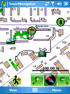
فيتو smartmap -- نظام الملاحة النظام العالمي لتحديد المواقع لجيب جهاز كمبيوتر شخصي. Smartmap يستخدم ناقل الميثاق وخرائط خطوط المسح ، والتي هي المثل الأعلى لالسفر سيرا على الاقدام وبالسيارات. البرنامج يتيح لك عرض الخرائط لتحديد موقعك على الخريطه ، انظر الى مسارك ، وتركيبها وصيانتها على علامة الطريق ، وكذلك لتصدير الملفات في شكل معهد بحوث النظم البيءيه.
التوافق مع النظام العالمى لتحديد المواقع لأي جهاز الاستقبال! عادل النظام العالمي لتحديد المواقع ، وجهاز الاستقبال smartmap يجد ، وتبين لكم تحديد احداثيات موقعك على الخريطه. فيتو smartmap يوفر المعيار دقة النظام العالمي لتحديد المواقع النظام العالمي لتحديد المواقع : اكثر سواتل الشبكه يمكن العثور على جهاز الاستقبال الخاص بك ، وأدق ستكون النتائج. افضل النتائج تتحقق عندما موقع لا يقل عن اربعة سواتل في الجزء المرئي من السماء. بعض العوامل الأخرى مثل الغيوم وتال المبانى وغيرها من العقبات التي تقلل من دقة تحديد المواقع.
العرض السريع للناقل خرائط
وفي الفترة هو ضخم جمع الخرائط من مختلف بلدان النطاق 1:1 000000 ، الذي يحمل الطرق الرئيسية والبلدات والقرى والغابات ، والمطارات ، والانهار والبحيرات.
تسجيل الطريق
مع هذه الميزه يمكنك استخدام فيتو smartmap حتى بدون خرائط! وتشمل سجل كطريق ، ثم وجدت ان الطريق الى الوراء أو الى خلق بنفسك خارطه الطريق.
عرض الاتجاه ، والسرعه ، وحجمه ، وارتفاع والبوصلة.
مع هذه المعلومات ، فقد كنت أبدا!
دعم العلامات (نقاط الطريق) ، وتنسق مع الحواشي.
التغييرات في النسخه الحالية :
-- لقد بدأ هذا البرنامج الى العمل في اسرع 15-30 ٪
-- يدعم ويندوز موبايل 5،0
الدعم : وم 2003/2003 (سي) ، وم 5،0 ، 6،0 وم
VITO SmartMap - GPS navigation system for Pocket PC. SmartMap uses compact vector and raster maps, which are ideal for travel on foot and by car. The program lets you view maps to determine your location on the map, to see your route, install and maintain a label route, as well as to export files in ESRI format.
Compatibility with any GPS receiver! Just GPS, receiver and SmartMap find, identify and show you the coordinates of your location on the map. VITO SmartMap provides a standard accuracy of GPS global positioning system: the more GPS satellites can find your receiver, the more accurate the results will be. The best results are achieved when the location of at least four satellites in the visible part of the sky. Such factors as clouds and tall buildings and other obstacles reduce the accuracy of positioning.
Rapid display of vector maps
At the interval is a huge collection of maps of various countries of scale 1:1 000000, which bears the main roads, towns, villages, forests, airports, rivers and lakes.
Recording route
With this feature you can use VITO SmartMap even without maps! Include record a route, then finding that the road or backward to create your own road map.
Displaying the direction, speed, size, height and compass.
With this information, you never lost!
Support labels (waypoints), and coordinates with notes.
Changes in Current Version:
-- the program began to work faster at 15-30%
-- supports Windows mobile 5.0
Support: WM 2003/2003 (SE), WM 5.0, WM 6.0
طريقة التحميل
Download VITO SmartMap Size: 1.89 MB
Download Vito Map Manager Size: 4.44 MB